The property surveying profession stands at a technological crossroads in 2026. While traditional surveying methods involving bulky total stations and weeks of fieldwork remain commonplace, a revolutionary approach is transforming how forward-thinking surveyors capture spatial data. Mobile 3D mapping for property surveyors: creating accurate digital twins in minutes represents more than incremental improvement—it's a fundamental reimagining of the surveying workflow that's reducing project timelines from weeks to hours while maintaining or exceeding traditional accuracy standards.
This transformation is driven by converging technologies: miniaturized LiDAR sensors, artificial intelligence-powered data processing, and cloud-based collaboration platforms. Leading surveying firms now deploy compact, handheld devices that capture millions of data points per second, automatically processing this information into detailed 3D models that clients can explore through web browsers within hours of site visits. The implications extend far beyond efficiency gains, opening new service opportunities in building surveys, asset management, and environmental monitoring that were previously economically unfeasible.
Key Takeaways
✅ Dramatic time reduction: Mobile 3D mapping systems reduce on-site surveying from weeks to as little as half a day while maintaining deliverable quality[2]
✅ Market growth: The global mobile mapping market is projected to reach $66.7 billion by 2026, driven by smart city investments and advanced surveying technology adoption[5][9]
✅ AI-powered processing: Artificial intelligence automatically classifies point cloud data, detects errors, and identifies patterns with impressive precision, eliminating hours of manual work[2]
✅ Flexible deployment: Modern mobile mapping hardware works in GPS-denied environments (indoor spaces, underground sites) using SLAM technology, expanding surveying capabilities beyond traditional limitations[6]
✅ Cloud collaboration: Clients now expect instant 3D visualization, real-time revision syncing, and integrated communication through browser-based platforms rather than static PDF deliverables[4]
Understanding Mobile 3D Mapping Technology for Property Surveyors
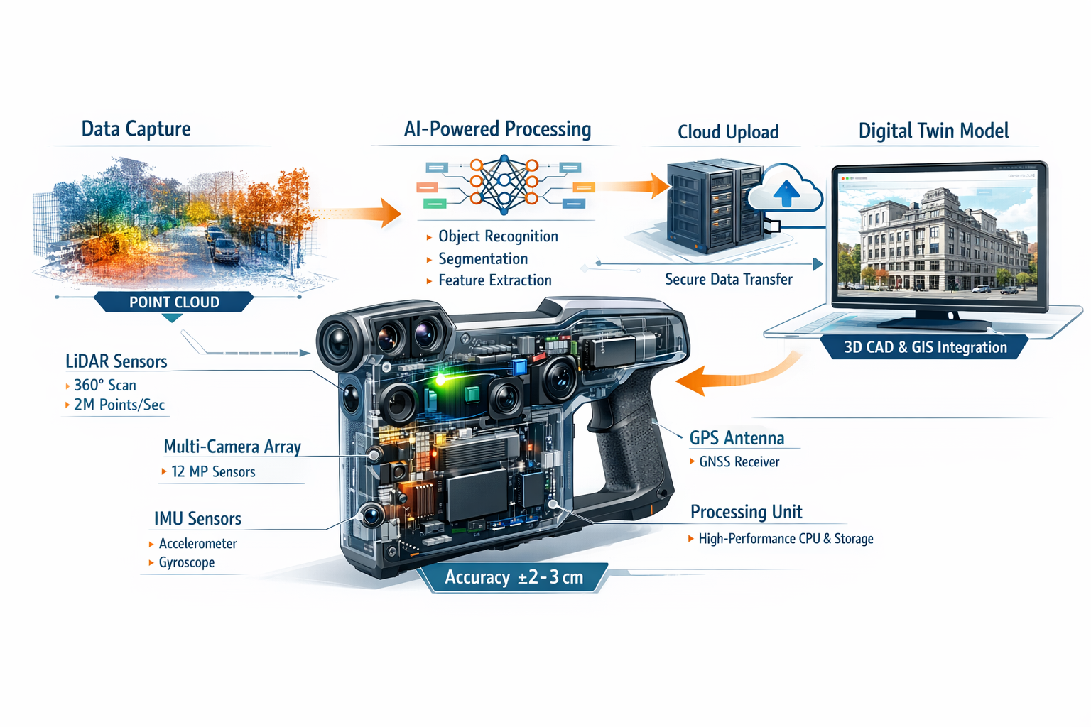
Mobile 3D mapping represents a paradigm shift from stationary measurement to continuous data capture while moving through a space. Unlike traditional surveying that requires setting up equipment at multiple control points, mobile mapping systems combine LiDAR sensors, multiple cameras, inertial measurement units (IMUs), and GPS receivers into compact devices that surveyors carry or mount on vehicles.
How Mobile Mapping Systems Work
The technology operates through simultaneous localization and mapping (SLAM), a computational approach that builds a map of an unknown environment while tracking the device's position within that space. As the surveyor walks through a property, the system:
- Emits laser pulses that bounce off surfaces and return to the sensor
- Captures high-resolution imagery from multiple camera angles
- Measures motion and orientation through IMU sensors
- Processes data in real-time to create a georeferenced point cloud
- Identifies and corrects drift through loop closure algorithms
This continuous capture approach generates dense point clouds—collections of millions of precisely positioned 3D coordinates that represent every surface, object, and architectural feature within the scanned environment.
Key Components of Mobile Mapping Hardware
| Component | Function | 2026 Capabilities |
|---|---|---|
| LiDAR Sensor | Measures distances using laser pulses | 300,000+ points/second, 100m+ range |
| Camera Array | Captures high-resolution imagery | 4K+ resolution, HDR, 360° coverage |
| IMU | Tracks device orientation and motion | Sub-degree accuracy, 1000Hz sampling |
| GPS/GNSS | Provides outdoor positioning | Multi-constellation, RTK-enabled |
| Processing Unit | Computes SLAM algorithms | Real-time processing, AI acceleration |
| Storage | Stores raw scan data | 1TB+ solid-state, hot-swappable |
The miniaturization trend has been particularly significant. Modern mobile mapping devices weigh as little as 2-3 kilograms compared to 15-20 kilogram systems from just five years ago, making them accessible to smaller surveying firms and enabling single-operator deployment[2].
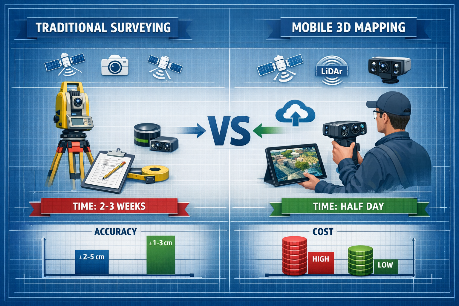
Mobile Mapping vs. Traditional Surveying Methods
The contrast between mobile 3D mapping for property surveyors: creating accurate digital twins in minutes and conventional approaches becomes clear when examining typical project workflows:
Traditional Total Station Approach:
- ⏱️ Time: 2-3 weeks for medium commercial property
- 👥 Personnel: 2-3 surveyors minimum
- 📊 Data density: Hundreds to thousands of measured points
- 🔄 Revisits: Often required for missed measurements
- 📄 Deliverable: 2D CAD drawings, limited 3D visualization
Mobile 3D Mapping Approach:
- ⏱️ Time: Half-day to one day for same property
- 👥 Personnel: Single operator possible
- 📊 Data density: Millions of captured points
- 🔄 Revisits: Rarely needed due to comprehensive capture
- 📄 Deliverable: Full 3D digital twin, 2D extractions, immersive tours
This efficiency improvement transforms project economics. Surveying firms report being able to accept more projects with existing staff or reduce costs while maintaining margins—competitive advantages that are reshaping the industry landscape[2].
Implementing Mobile 3D Mapping for Property Surveyors: Creating Accurate Digital Twins in Minutes
Successfully integrating mobile mapping technology into established surveying practices requires more than purchasing equipment. The transition involves workflow redesign, staff training, and strategic decisions about which projects benefit most from the technology.
Selecting the Right Mobile Mapping System
Not all mobile mapping solutions suit every surveying application. Property surveyors should evaluate systems based on several critical factors:
Indoor vs. Outdoor Requirements
For surveyors primarily conducting RICS building surveys and interior assessments, SLAM-based systems that function without GPS signals are essential. These devices use visual and geometric features to maintain positioning accuracy in GPS-denied environments like multi-story buildings, basements, and underground facilities[6].
Conversely, surveyors focusing on boundary work, topographic surveys, or large site assessments benefit from vehicle-mounted systems with high-precision GPS/GNSS integration that can cover extensive areas quickly.
Accuracy Requirements
Mobile mapping accuracy typically ranges from ±1-3 centimeters for high-end systems to ±5-10 centimeters for entry-level devices. This compares favorably with traditional surveying methods for most property applications, though specialized work like subsidence surveys may still require supplementary total station measurements at critical control points.
The accuracy specification should match deliverable requirements. For schedule of condition reports and general documentation, moderate accuracy suffices. For engineering projects requiring precise dimensional control, higher-specification systems justify their premium cost.
Data Processing Workflow
The survey doesn't end when scanning completes. Consider the post-processing ecosystem:
- Proprietary vs. open formats: Systems outputting standard formats (LAS, E57, OBJ) provide flexibility
- Processing time: Real-time vs. hours of post-processing affects project turnaround
- Software requirements: Additional licenses for CAD extraction, BIM integration, or analysis tools
- Cloud integration: Automatic upload and browser-based viewing capabilities
Advanced photogrammetry software in 2026 supports diverse data sources including drones, LiDAR, SLAM mappers, and even sonar data for underwater mapping applications, enabling comprehensive surveying of coastal properties, dam sites, and lakebeds[6].
Training and Workflow Integration
The shift to mobile 3D mapping requires surveyors to "think beyond 2D maps and start looking at 3D objects"—a conceptual transition that goes beyond equipment operation[2].
Essential Training Components:
📚 Technical operation: Device setup, calibration procedures, scanning techniques
📚 Data quality assessment: Recognizing coverage gaps, identifying registration errors
📚 Software proficiency: Point cloud processing, feature extraction, deliverable creation
📚 Client communication: Explaining 3D deliverables, providing viewing instructions
Many surveying firms implement a phased adoption strategy, initially deploying mobile mapping on less time-sensitive projects while maintaining traditional methods as backup. This approach builds confidence and allows refinement of workflows before committing to mobile-first operations.
Project Planning and Field Procedures
Successful mobile mapping projects begin with thorough planning:
Pre-Survey Preparation
- Review site plans and identify areas of interest
- Determine optimal scanning routes to minimize coverage gaps
- Establish control points for accuracy verification
- Assess lighting conditions and plan for supplementary illumination
- Coordinate site access and safety requirements
Field Scanning Best Practices
- Maintain consistent walking speed (typically 0.5-1.0 m/s)
- Ensure 30-40% overlap between scan passes
- Create loop closures by returning to starting positions
- Capture control targets for georeferencing
- Document challenging areas requiring additional attention
- Verify data quality through real-time preview before leaving site
The single-operator capability of modern mobile mapping systems represents a significant cost advantage, though complex properties may still benefit from two-person teams for safety and efficiency[2].
Quality Control and Accuracy Verification
Even with automated processing, surveyors maintain professional responsibility for deliverable accuracy. Effective quality control procedures include:
✔️ Registration accuracy checks: Verify alignment at scan overlaps and loop closures
✔️ Control point comparison: Measure deviations from known coordinates
✔️ Completeness review: Identify and address coverage gaps
✔️ Noise filtering: Remove erroneous points from reflective surfaces, moving objects
✔️ Dimensional verification: Confirm critical measurements against traditional methods
For projects requiring certification or legal defensibility—such as expert witness work or boundary surveys—supplementing mobile mapping with traditional control measurements provides additional validation and professional confidence.
Creating Digital Twins: From Point Clouds to Actionable Deliverables
Capturing millions of data points represents only the first step. The true value of mobile 3D mapping for property surveyors: creating accurate digital twins in minutes emerges through transforming raw point clouds into meaningful deliverables that clients can use for decision-making.
Understanding Digital Twins in Property Surveying
A digital twin is a virtual replica of a physical asset that accurately represents its geometry, spatial relationships, and—increasingly—its attributes and condition. For property surveyors, digital twins serve multiple purposes:
🏢 Documentation: Permanent record of existing conditions at a specific point in time
🏢 Analysis: Platform for dimensional verification, area calculations, volume measurements
🏢 Visualization: Immersive client presentations and stakeholder communication
🏢 Integration: Foundation for BIM models, renovation planning, facility management systems
The intersection of 3D GIS, advanced modeling, and spatial data capture is creating demand for surveyors who deliver data feeding comprehensive asset lifecycle management systems for municipalities, state agencies, and private infrastructure owners managing aging infrastructure with constrained resources[7].
AI-Powered Point Cloud Processing
Artificial intelligence and deep learning are revolutionizing how surveyors extract meaning from point cloud data. Modern processing software automatically:
- Classifies points into categories (walls, floors, ceilings, furniture, vegetation)
- Detects features like doors, windows, structural elements, MEP systems
- Identifies anomalies such as structural deformations, water damage, settlement
- Generates floor plans by extracting horizontal sections at specified heights
- Creates building models through automated surface reconstruction
This AI-powered automation achieves "impressive precision" while reducing manual processing time from days to hours[2]. For commercial property surveyors, this efficiency enables competitive pricing on projects that would have been economically marginal using traditional methods.
Privacy Protection Through AI
Real-time anonymization techniques now blur faces and vehicle registration plates at the point of data collection, addressing privacy concerns that previously complicated mobile mapping in occupied buildings and public spaces[2].
Deliverable Formats and Client Expectations
Client expectations have evolved dramatically. In 2026, property owners and developers expect instant file sharing, 3D visualization in browsers, real-time revision syncing, and integrated communication with engineers and architects through cloud-based platforms[4].
Standard Deliverable Package:
📦 Interactive 3D model: Browser-based point cloud viewer with measurement tools
📦 2D floor plans: CAD drawings extracted from scan data
📦 Elevations and sections: Generated from any viewing angle
📦 Orthophotos: Geometrically corrected imagery for facade documentation
📦 Measurement report: Dimensions, areas, volumes as required
📦 Condition documentation: Annotated imagery highlighting defects or features
For specialized applications like stock condition surveys, the digital twin becomes a permanent reference enabling future condition comparison and deterioration tracking.
Integration with Existing Surveying Services
Mobile 3D mapping enhances rather than replaces traditional surveying services. Successful firms integrate the technology across their service portfolio:
Building Surveys and Inspections
Mobile mapping provides comprehensive documentation for homebuyer surveys and specialist defect surveys, creating permanent records that support written reports and enable remote consultation with specialists.
Commercial Property Assessment
For commercial building surveys, digital twins facilitate area verification, lease compliance documentation, and renovation planning. The comprehensive capture reduces return visits when clients request additional measurements.
Dilapidations and Condition Reports
Schedule of dilapidations work benefits enormously from timestamped 3D documentation that provides indisputable evidence of property condition at lease commencement or termination.
Structural Engineering Coordination
Digital twins serve as the foundation for structural surveys and beam calculations, providing engineers with accurate dimensional data and spatial context for their analysis.
Expanding Service Offerings Through Mobile Mapping
The efficiency and comprehensiveness of mobile 3D mapping enable surveying firms to expand into previously inaccessible markets:
Environmental Monitoring
Land surveyors are playing an increasingly crucial role in assessing and mitigating environmental impacts, with surveying data supporting sustainable land development and responsible resource management[4]. Mobile mapping enables cost-effective monitoring of erosion, vegetation encroachment, and environmental compliance.
Disaster Response and Documentation
The speed of mobile mapping makes it ideal for post-disaster assessment, insurance claims documentation, and emergency response planning. Firms equipped with mobile systems can respond rapidly to time-sensitive situations.
Urban Planning and Smart Cities
Smart city investments are a primary driver of the mobile mapping market's growth to $66.7 billion by 2026[5]. Surveying firms positioned to provide 3D urban models, infrastructure inventories, and spatial analytics can access lucrative municipal contracts.
Broadcasting and Media Applications
Innovative applications continue to emerge. A French surveying company charted the 2024 Olympics marathon route, producing 3D models used by broadcasters for television replays and advertisement placement[2]—demonstrating how surveying expertise combined with advanced technology creates entirely new revenue streams.
The Future Landscape: Industry Trends and Strategic Positioning
The surveying profession is experiencing fundamental transformation driven by technological advancement, changing client expectations, and market consolidation. Understanding these trends helps firms make strategic decisions about technology investment and service development.
Market Dynamics and Growth Drivers
The mobile mapping market's projected growth from $27.3 billion in 2021 to $66.7 billion by 2026 reflects multiple converging factors[5][9]:
📈 Smart city initiatives: Governments worldwide are investing in digital infrastructure requiring comprehensive spatial data
📈 Infrastructure aging: Developed nations face mounting infrastructure maintenance challenges requiring detailed asset documentation
📈 BIM adoption: Building information modeling mandates are driving demand for accurate as-built documentation
📈 Geospatial data utilization: Organizations across sectors recognize spatial data as a strategic asset
This growth creates opportunities for surveying firms that position themselves as spatial data providers rather than traditional measurement services.
Technology Evolution and Convergence
Several technological trends will shape surveying practice through the remainder of the decade:
Hardware Miniaturization and Accessibility
Mobile mapping hardware continues becoming smaller, lighter, and more affordable with advanced camera resolution and real-time processing capabilities[2]. This democratization enables smaller surveying firms to compete with larger organizations on technological capability.
UAV Integration
Unmanned aerial vehicles have become "much cheaper and more accessible" with capabilities extending beyond basic surveys to photogrammetry, 3D mapping, multispectral maps, thermal maps, 2D/3D orthomosaic maps, and building information modeling[1]. The combination of ground-based mobile mapping and drone surveys provides comprehensive site documentation from all perspectives.
Multi-Sensor Data Fusion
Advanced systems now integrate data from diverse sources—terrestrial LiDAR, mobile mapping, aerial photogrammetry, and even sonar—into unified models that provide complete spatial representation[6]. This multi-platform approach enables surveying in challenging environments like coastal zones, underground facilities, and complex industrial sites.
Real-Time Processing and Edge Computing
The shift from post-processing to real-time data generation continues accelerating. Surveyors increasingly deliver preliminary models while still on-site, enabling immediate client feedback and reducing the need for return visits.
Workflow Transformation: From 2D to 3D Thinking
The industry is undergoing a fundamental paradigm shift where surveyors must "think beyond 2D maps and start looking at 3D objects" to meet client demands[2]. This includes adoption of 3D cadastres for more accurate representation of multidimensional urban spaces[2][3].
This transition requires:
- Revised educational curricula emphasizing 3D spatial thinking
- Software proficiency beyond traditional CAD into 3D modeling and visualization
- Communication skills to explain complex 3D deliverables to non-technical clients
- Data management strategies for handling much larger file sizes
Firms that successfully navigate this transition position themselves as modern spatial data providers rather than traditional surveyors—a distinction that commands premium pricing and attracts forward-thinking clients.
Competitive Landscape and Market Consolidation
The surveying industry is experiencing consolidation patterns where smaller firms grow into mid-sized companies, which are frequently acquired by larger geospatial organizations creating departments spanning engineering, surveying, environmental services, and related disciplines[2].
This consolidation creates strategic choices for surveying practices:
Specialization Strategy: Focus on niche applications (heritage documentation, industrial facilities, specialized defects) where expertise and client relationships provide competitive moats
Technology Leadership: Invest heavily in cutting-edge equipment and position as the technology-forward option in the market
Geographic Expansion: Use mobile mapping efficiency to serve wider territories with existing staff, becoming the regional provider across multiple locations
Integration and Exit: Build comprehensive service offerings attractive to larger acquirers seeking geographic presence or capability expansion
For established surveying firms serving specific regions—whether chartered surveyors in Buckinghamshire, Surrey, Hertfordshire, or other areas—mobile 3D mapping technology enables maintaining local market leadership while expanding service capabilities.
Regulatory and Professional Standards Evolution
Professional surveying organizations are adapting standards to accommodate new technologies while maintaining quality and ethical requirements. Surveyors should anticipate:
- Updated accuracy standards specifically addressing mobile mapping methodologies
- Digital deliverable specifications defining requirements for 3D models and point clouds
- Data management protocols addressing storage, archiving, and long-term accessibility
- Professional development requirements ensuring practitioners maintain current technical competence
Staying engaged with professional organizations and participating in standards development ensures firms can influence regulations rather than merely react to them.
Overcoming Implementation Challenges
Despite clear advantages, mobile 3D mapping adoption faces practical challenges that surveying firms must address:
Initial Investment and ROI Considerations
Equipment costs for professional-grade mobile mapping systems range from £15,000 for entry-level devices to £100,000+ for high-end solutions. Additional expenses include:
- Processing software licenses (£2,000-£10,000 annually)
- Cloud storage and collaboration platforms (£500-£2,000 monthly)
- Training and certification (£1,000-£5,000 per surveyor)
- Backup and redundancy equipment
Calculating return on investment requires realistic assessment of:
✓ Time savings per project: Quantify reduced field time and processing hours
✓ Increased project capacity: Additional projects possible with existing staff
✓ Premium pricing potential: Client willingness to pay for enhanced deliverables
✓ New service opportunities: Revenue from previously unfeasible project types
✓ Competitive positioning: Market share gains from technology leadership
Most firms report payback periods of 12-24 months when mobile mapping is integrated into regular workflow rather than reserved for special projects.
Data Management and Storage Requirements
Point cloud data files are substantially larger than traditional survey data. A comprehensive building scan can generate 50-200 gigabytes of raw data, with processed deliverables adding significant additional storage requirements.
Effective data management strategies include:
🗄️ Tiered storage architecture: Hot storage for active projects, cold storage for archives
🗄️ Cloud backup systems: Redundant off-site storage protecting against data loss
🗄️ Retention policies: Clear guidelines for how long raw data is maintained
🗄️ Naming conventions: Consistent file organization enabling efficient retrieval
🗄️ Metadata standards: Comprehensive project information facilitating future use
Client Education and Expectation Management
Many clients remain unfamiliar with 3D deliverables and may initially resist departures from traditional 2D plans. Successful firms address this through:
- Demonstration projects: Offering mobile mapping at reduced rates to showcase capabilities
- Interactive presentations: Letting clients explore 3D models during proposal meetings
- Hybrid deliverables: Providing both traditional 2D outputs and enhanced 3D models
- Training and support: Teaching clients to use viewing software and extract value from digital twins
The effort invested in client education creates competitive differentiation and justifies premium pricing for enhanced deliverables.
Technical Limitations and Appropriate Application
Mobile mapping is not universally superior to traditional methods. Surveyors must recognize situations where conventional approaches remain preferable:
⚠️ High-precision control surveys: Sub-centimeter accuracy requirements may exceed mobile mapping capabilities
⚠️ Outdoor sites with poor GPS: Dense tree canopy or urban canyons can degrade positioning accuracy
⚠️ Highly reflective environments: Glass facades and polished surfaces create challenging scanning conditions
⚠️ Legal boundary determination: Cadastral surveys often require traditional monumentation and measurement
The most successful implementations use mobile mapping as a complement to traditional methods rather than a complete replacement, selecting the optimal approach for each project's specific requirements.
Practical Implementation Roadmap
For surveying firms ready to adopt mobile 3D mapping technology, a structured implementation approach maximizes success probability:
Phase 1: Assessment and Planning (Months 1-2)
- Analyze current project portfolio identifying mobile mapping opportunities
- Research available systems matching your specific requirements
- Develop business case with realistic ROI projections
- Secure financing or budget allocation
- Identify early-adopter clients willing to participate in pilot projects
Phase 2: Acquisition and Training (Months 2-4)
- Purchase equipment and software licenses
- Complete manufacturer training and certification
- Conduct internal practice projects on familiar properties
- Develop standard operating procedures and quality control protocols
- Create template deliverables and presentation materials
Phase 3: Pilot Projects (Months 4-6)
- Execute 3-5 pilot projects with supportive clients
- Maintain traditional methods as backup during learning phase
- Document lessons learned and refine workflows
- Build portfolio of example deliverables
- Calculate actual time savings and cost impacts
Phase 4: Full Integration (Months 6-12)
- Make mobile mapping the default approach for suitable projects
- Develop marketing materials highlighting new capabilities
- Train all relevant staff on equipment operation and data processing
- Establish partnerships with complementary service providers
- Expand into new service areas enabled by technology
Phase 5: Optimization and Expansion (Months 12+)
- Analyze project data to identify efficiency improvements
- Consider additional equipment for capacity expansion
- Develop specialized expertise in high-value niches
- Explore advanced applications (AI analysis, predictive modeling)
- Share knowledge through professional organizations and publications
Conclusion: Embracing the Digital Transformation of Property Surveying

Mobile 3D mapping for property surveyors: creating accurate digital twins in minutes represents far more than a technological upgrade—it's a fundamental reimagining of how surveying professionals capture, process, and deliver spatial information. The convergence of miniaturized sensors, artificial intelligence, and cloud-based collaboration has created capabilities that were science fiction just a decade ago, now available to surveying practices of all sizes.
The evidence is compelling: firms adopting mobile mapping reduce field time from weeks to days while capturing exponentially more data than traditional methods. They expand service offerings into environmental monitoring, asset management, and urban planning. They meet evolving client expectations for instant digital access and interactive 3D visualization. Most importantly, they position themselves for continued relevance as the industry completes its transition from 2D documentation to comprehensive digital twins.
Key Success Factors
Successful mobile mapping implementation requires:
✅ Strategic equipment selection matching system capabilities to actual project requirements
✅ Comprehensive training ensuring staff can operate equipment and process data effectively
✅ Workflow integration making mobile mapping the default rather than the exception
✅ Client education demonstrating value and justifying premium pricing
✅ Quality control maintaining professional standards despite automation
✅ Continuous learning staying current with rapidly evolving technology
Taking Action: Next Steps for Your Surveying Practice
Whether you're a sole practitioner or part of a larger organization, the time to engage with mobile 3D mapping technology is now. The market is growing at double-digit rates, client expectations are evolving, and competitive advantages accrue to early adopters.
Immediate Actions:
- Assess your current project portfolio to identify which services would benefit most from mobile mapping capabilities
- Research available systems by attending demonstrations, speaking with vendors, and consulting with firms already using the technology
- Develop a business case with realistic projections of time savings, capacity increases, and new revenue opportunities
- Identify pilot projects with clients willing to participate in your technology adoption journey
- Engage with professional organizations to access training resources and best practice guidance
Long-Term Strategic Considerations:
- How will mobile mapping enable expansion into new geographic markets or service areas?
- What complementary technologies (drones, AI analysis, BIM integration) should be part of your technology roadmap?
- How should marketing and client communication evolve to highlight enhanced capabilities?
- What partnerships with engineers, architects, or facility managers could create synergistic opportunities?
The surveying profession has always evolved alongside measurement technology—from chains and theodolites to total stations and GPS. Mobile 3D mapping represents the next chapter in this evolution, offering unprecedented efficiency, comprehensiveness, and client value. Firms that embrace this transformation position themselves not merely as surveyors, but as essential spatial data providers in an increasingly digital built environment.
The digital twin revolution is here. The question is not whether to participate, but how quickly your practice can adapt to lead rather than follow this fundamental industry transformation.
References
[1] The Future Of Land Surveying Technology And Upcoming Trends In 2026 – https://metricop.com/blogs/land-surveying/the-future-of-land-surveying-technology-and-upcoming-trends-in-2026
[2] Surveying Geospatial Industry Trends 2025 Ai Mobile Mapping 3d – https://www.geoweeknews.com/blogs/surveying-geospatial-industry-trends-2025-ai-mobile-mapping-3d
[3] Land Surveying Propelled Into The Future With Ai And Drones – https://resource-erectors.com/land-surveying-propelled-into-the-future-with-ai-and-drones/
[4] Future Land Surveying 2026 – https://haller-blanchard.com/future-land-surveying-2026/
[5] Mobile Mapping – https://www.marketsandmarkets.com/PressReleases/mobile-mapping.asp
[6] 3dsurvey Is The Best Photogrammetry Software In 2026 – https://3dsurvey.si/3dsurvey-is-the-best-photogrammetry-software-in-2026/
[7] Doubling Down On Digital – https://amerisurv.com/2026/02/01/doubling-down-on-digital/
[9] Mobile Mapping Market Worth 66 7 Billion In 2026 Exclusive Report By Marketsandmarkets 301457180 – https://www.prnewswire.com/news-releases/mobile-mapping-market-worth-66-7-billion-in-2026–exclusive-report-by-marketsandmarkets-301457180.html