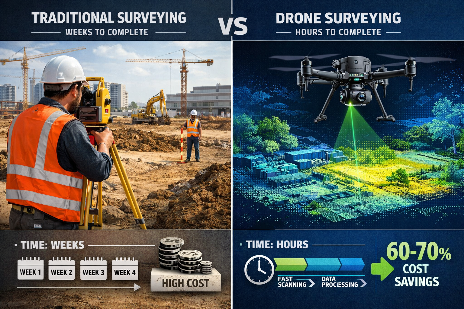
The property surveying industry stands at a technological crossroads in 2026, where affordable drone technology is fundamentally transforming how professionals capture, analyze, and deliver critical land data. What once required weeks of labor-intensive ground measurements can now be accomplished in hours with unmanned aerial vehicles (UAVs) equipped with advanced sensors. The convergence of cheaper, more accessible drones with high-resolution cameras and LiDAR (Light Detection and Ranging) technology is revolutionizing large-scale topographic surveys and land management practices across the globe. This shift isn't just about speed—it's about democratizing precision surveying for firms of all sizes while delivering unprecedented return on investment.
As we explore Drones in Property Surveying: 2026 Advancements in UAVs, LiDAR, and Aerial Data Capture, the evidence is clear: surveying professionals who embrace this technology gain significant competitive advantages, reduce operational costs by 60-70%, and deliver more comprehensive data to clients. The question is no longer whether to adopt drone technology, but how quickly firms can integrate these tools into their workflows.
Key Takeaways
✅ Cost Reduction: Modern drone surveying systems reduce operational costs by 60-70% compared to traditional ground-based methods while improving accuracy and data completeness.
✅ Accessibility Revolution: Entry-level survey-grade drones with integrated LiDAR now start under £15,000, making advanced aerial data capture accessible to small and medium-sized surveying firms.
✅ ROI Timeline: Most surveying firms achieve complete return on investment within 8-12 months of drone adoption through increased project capacity and reduced labor requirements.
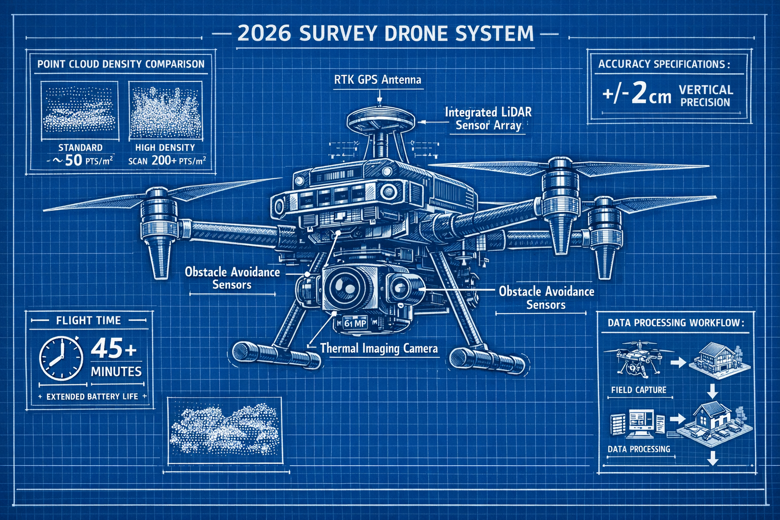
✅ Data Quality Leap: 2026 drone systems capture point cloud densities exceeding 200 points per square meter with vertical accuracy of ±2cm, surpassing many traditional surveying methods.
✅ Regulatory Maturity: Streamlined regulations and automated compliance systems in 2026 make commercial drone operations more straightforward than ever before.
The Evolution of Drone Technology in Property Surveying
From Expensive Novelty to Essential Tool
The transformation of drones from expensive, specialist equipment to mainstream surveying tools represents one of the most significant shifts in the profession's history. In 2020, professional survey-grade drones with LiDAR capabilities commanded prices exceeding £100,000, placing them beyond reach for all but the largest firms. By 2026, technological advancement and market competition have driven prices down dramatically while simultaneously improving performance metrics.
Modern entry-level survey drones now feature:
- Integrated LiDAR sensors with 300-meter range
- High-resolution cameras (61+ megapixels)
- RTK GPS positioning for centimeter-level accuracy
- Obstacle avoidance systems for safer autonomous flight
- Extended flight times (45+ minutes per battery)
- Automated mission planning software
This democratization of technology means that firms conducting different types of survey can now integrate aerial data capture into their standard service offerings without prohibitive capital investment.
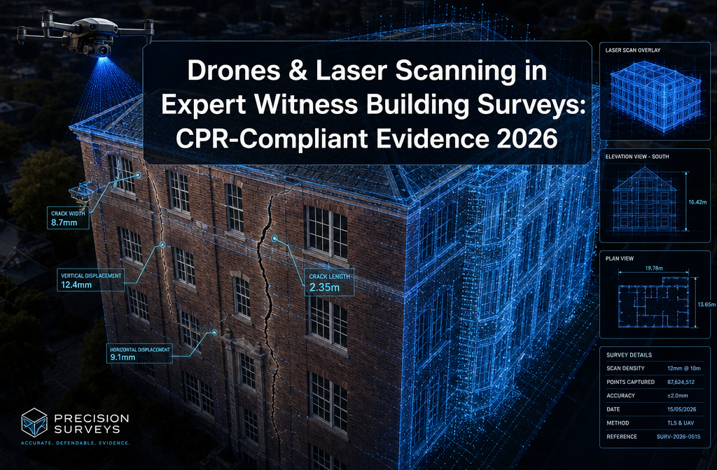
The LiDAR Revolution in Aerial Surveying
LiDAR technology has emerged as the game-changing component in Drones in Property Surveying: 2026 Advancements in UAVs, LiDAR, and Aerial Data Capture. Unlike traditional photogrammetry, which relies on overlapping photographs to create 3D models, LiDAR uses laser pulses to directly measure distances and create highly accurate point clouds.
Key advantages of drone-mounted LiDAR include:
| Feature | Traditional Photogrammetry | Drone LiDAR (2026) |
|---|---|---|
| Vegetation penetration | Limited | Excellent (multi-return) |
| Accuracy (vertical) | ±5-10cm | ±2cm |
| Point cloud density | 50-100 pts/m² | 200+ pts/m² |
| Weather dependency | High (needs sunlight) | Moderate |
| Processing time | 4-8 hours | 1-2 hours |
| Cost per hectare | £200-400 | £150-250 |
The ability to penetrate vegetation canopy and capture ground-level topography makes LiDAR particularly valuable for large-scale land management projects, forestry surveys, and infrastructure planning. Surveyors conducting structural surveys can now obtain comprehensive site data that was previously impossible to capture efficiently.
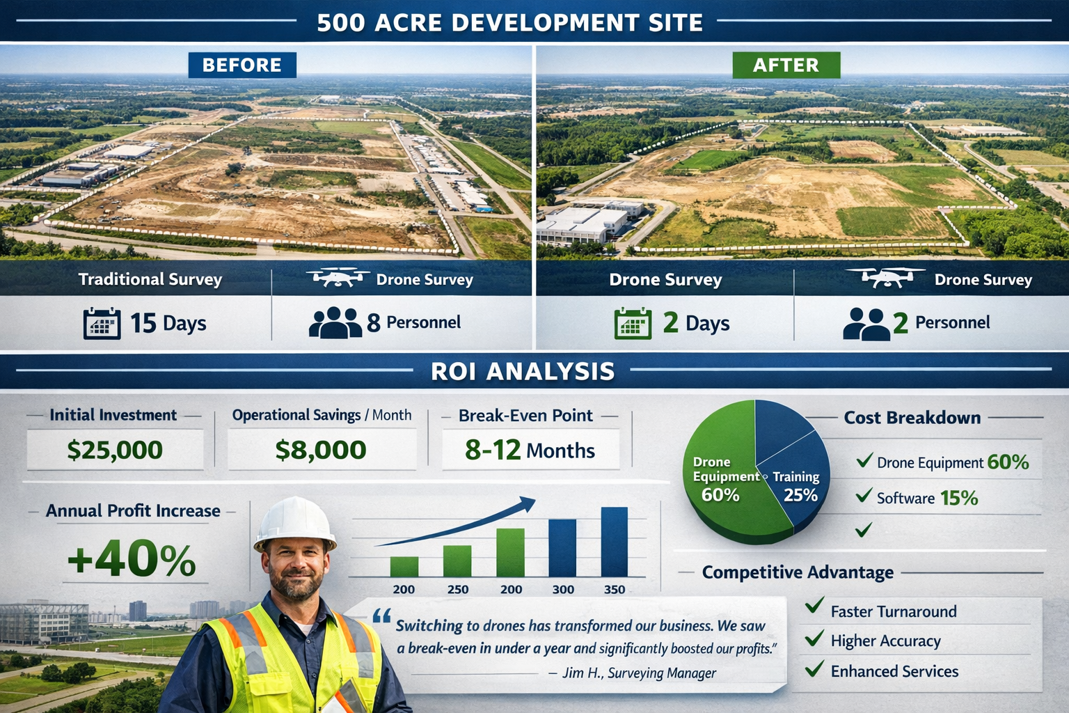
ROI Analysis: The Business Case for Drone Adoption
Real-World Cost Comparisons
Understanding the financial impact of drone technology requires examining actual project data from surveying firms that have made the transition. The numbers reveal compelling advantages that extend beyond simple time savings.
Case Study 1: Medium-Sized Surveying Firm (East Anglia)
A 12-person surveying practice specializing in homebuyer surveys and commercial property assessments invested £28,000 in a complete drone surveying package in early 2025. Their results after 12 months:
- Initial investment: £28,000 (drone, sensors, software licenses, training)
- Projects completed: 47 aerial surveys
- Revenue generated: £94,000 (new service offerings)
- Labor cost savings: £31,000 (reduced field time)
- Total financial benefit: £125,000
- Net ROI: 346% in first year
- Break-even point: 8.5 months
The firm reported that drone capabilities allowed them to bid competitively on larger commercial projects previously beyond their capacity, while simultaneously reducing the time required for RICS home surveys on properties with extensive grounds.
Case Study 2: Specialist Land Surveying Practice (Scotland)
A topographic surveying specialist serving agricultural and renewable energy sectors invested £45,000 in advanced LiDAR-equipped systems:
- Initial investment: £45,000 (high-end LiDAR drone, processing workstation)
- Annual operational savings: £89,000 (reduced crew size, vehicle costs)
- New project capacity: +65% (faster turnaround times)
- Client retention improvement: 23% (enhanced deliverables)
- Break-even point: 6.2 months
Hidden Cost Benefits
Beyond direct operational savings, drone adoption in Drones in Property Surveying: 2026 Advancements in UAVs, LiDAR, and Aerial Data Capture creates additional financial advantages:
🔹 Reduced insurance costs: Lower risk exposure compared to personnel working in hazardous terrain
🔹 Vehicle fleet reduction: Fewer site visits mean lower fuel, maintenance, and vehicle capital costs
🔹 Competitive differentiation: Premium pricing for enhanced deliverables (3D models, orthomosaics, volumetric calculations)
🔹 Staff retention: Modern technology attracts and retains skilled professionals
🔹 Expanded service territory: Ability to serve remote locations efficiently
Firms offering property certification services report that drone-captured imagery provides superior documentation for compliance purposes, reducing liability risks and strengthening professional indemnity positions.
Technical Advancements Driving 2026 Capabilities
Sensor Integration and Data Fusion
The most significant advancement in Drones in Property Surveying: 2026 Advancements in UAVs, LiDAR, and Aerial Data Capture involves the seamless integration of multiple sensor types on single platforms. Modern survey drones combine:
Visual Spectrum Cameras
- 61-150 megapixel resolution
- Global shutter technology (eliminates rolling shutter distortion)
- Interchangeable lens systems
- Real-time image quality assessment
LiDAR Systems
- 300-500 meter effective range
- Multiple return capability (up to 5 returns per pulse)
- 500,000+ points per second measurement rate
- Integrated IMU (Inertial Measurement Unit) for precise positioning
Thermal Imaging
- 640×512 pixel thermal sensors
- Temperature measurement accuracy ±2°C
- Radiometric data capture for detailed analysis
- Useful for damp surveys and building diagnostics
Multispectral Sensors
- 5-10 band spectral imaging
- Vegetation health analysis
- Land use classification
- Environmental monitoring capabilities
This sensor fusion creates comprehensive datasets that provide surveyors with unprecedented insight into property conditions, terrain characteristics, and environmental factors.
Automated Processing and AI Integration
The 2026 landscape of drone surveying extends far beyond data capture. Artificial intelligence and machine learning algorithms now automate tasks that previously required extensive manual processing:
Automated Feature Extraction
- Building footprint detection and measurement
- Roof condition assessment and defect identification
- Vegetation classification and canopy analysis
- Infrastructure feature recognition (roads, utilities, boundaries)
Quality Control Systems
- Real-time data validation during flight operations
- Automatic gap detection and re-flight planning
- Point cloud noise filtering and classification
- Accuracy verification against ground control points
Deliverable Generation
- Automated orthomosaic creation
- Digital elevation model (DEM) production
- 3D mesh model generation
- Volumetric calculations and stockpile measurements
These automated workflows reduce processing time from days to hours, allowing surveyors to deliver results faster while maintaining rigorous quality standards. Professionals conducting registered RICS valuations benefit from comprehensive aerial documentation that supports valuation conclusions with objective, measurable data.
Battery Technology and Flight Duration
Battery limitations have historically constrained drone surveying operations, but 2026 brings significant improvements:
Current Generation Battery Performance:
- Flight duration: 45-55 minutes (survey-grade platforms)
- Recharge time: 30-40 minutes (fast charging systems)
- Battery lifespan: 400+ charge cycles
- Cold weather performance: Improved low-temperature operation
- Hot-swap systems: Continuous operations with minimal downtime
These improvements enable surveyors to cover larger areas in single site visits, reducing mobilization costs and improving project economics. A typical survey team can now capture 200+ hectares in a single day with appropriate planning and battery management.
Practical Applications Across Property Surveying Disciplines
Topographic and Boundary Surveys
Drone technology excels in large-scale topographic mapping, where traditional ground-based methods become prohibitively expensive. LiDAR-equipped drones capture comprehensive terrain data including:
- Contour mapping with 10-25cm interval precision
- Digital terrain models (DTM) showing bare earth surface
- Digital surface models (DSM) including all features
- Volumetric calculations for earthworks and material quantities
For boundary surveys, drones provide aerial context that helps identify historical boundary features, encroachments, and access issues that may not be apparent from ground level. The combination of high-resolution imagery and precise positioning data creates definitive records for boundary determination.
Building and Roof Surveys
Accessing roofs and elevated building features presents safety risks and logistical challenges in traditional surveying. Drone technology eliminates these concerns while improving data quality:
Roof Survey Capabilities:
- Complete photographic documentation from multiple angles
- Thermal imaging for moisture detection and insulation assessment
- 3D modeling for accurate area and pitch measurements
- Defect identification (missing tiles, damaged flashing, structural issues)
- Gutter and drainage system inspection
Surveyors offering roof surveys report that drone-captured data provides clients with visual evidence that supports recommendations and helps prioritize maintenance expenditure. The ability to inspect dangerous or inaccessible areas without scaffolding or cherry pickers reduces costs and improves safety outcomes.
Commercial and Industrial Applications
Large commercial properties, industrial facilities, and infrastructure projects benefit enormously from drone surveying capabilities:
Industrial Site Surveys:
- Stockpile volume measurement (±1-2% accuracy)
- Progress monitoring and verification
- As-built documentation
- Safety compliance monitoring
- Asset inventory and condition assessment
For firms conducting dilapidations surveys, drone technology provides comprehensive photographic evidence of property conditions at lease commencement and termination, reducing disputes and supporting objective assessments.
Agricultural and Rural Land Management
The agricultural sector has emerged as a major beneficiary of affordable drone technology in 2026. Multispectral imaging combined with LiDAR creates powerful land management tools:
- Crop health monitoring through NDVI (Normalized Difference Vegetation Index) analysis
- Drainage planning using precise elevation data
- Field boundary verification and area measurement
- Irrigation system design based on topographic analysis
- Environmental compliance documentation
Rural surveyors report that drone capabilities have opened new revenue streams while providing farmers with actionable data that improves operational efficiency and sustainability.
Regulatory Environment and Compliance in 2026
Streamlined Certification Processes
The regulatory framework governing commercial drone operations has matured significantly by 2026, with most jurisdictions implementing risk-based approaches that balance safety with operational flexibility.
UK CAA Requirements (2026):
- A2 Certificate of Competency for most commercial surveying operations
- Operational authorization for specific higher-risk scenarios
- Registration and marking of all commercial UAVs
- Insurance requirements: Minimum £1 million public liability coverage
- Privacy and data protection compliance under GDPR
The certification process has become more accessible, with online training modules and practical assessments available through approved training organizations. Most surveyors complete certification within 2-3 weeks of beginning the process.
Automated Compliance Systems
Modern drone systems incorporate automated compliance features that reduce the burden on operators:
🔹 Geo-fencing: Automatic prevention of flights in restricted airspace
🔹 Flight logging: Comprehensive records for regulatory compliance
🔹 Weather monitoring: Real-time assessment of safe operating conditions
🔹 Remote identification: Automated broadcast of drone location and operator details
🔹 Airspace authorization: Integrated systems for requesting temporary flight permissions
These automated systems significantly reduce the administrative overhead of commercial drone operations, allowing surveyors to focus on project delivery rather than compliance paperwork.
Privacy and Data Protection Considerations
Drone operations in populated areas raise legitimate privacy concerns that professional surveyors must address:
Best Practice Guidelines:
- Clear communication with property owners and neighbors
- Minimization of incidental capture of private areas
- Secure data storage and transmission protocols
- Defined retention and deletion policies
- Compliance with GDPR and data protection regulations
Professional bodies including RICS have published guidance on ethical drone use in property surveying, emphasizing transparency, proportionality, and respect for privacy rights.
Selecting the Right Drone System for Your Surveying Practice
Entry-Level Systems (£8,000-£20,000)
For practices beginning their drone journey or conducting occasional aerial surveys, entry-level systems offer excellent value:
Typical Specifications:
- High-resolution camera (20-48 megapixel)
- RTK GPS positioning (±2-5cm accuracy)
- 30-40 minute flight time
- Basic photogrammetry software
- Suitable for properties up to 50 hectares
These systems excel at homebuyer survey enhancement, small commercial properties, and residential development documentation. The lower capital investment makes them ideal for testing drone integration before committing to more advanced systems.
Mid-Range Professional Systems (£20,000-£50,000)
The mid-range category represents the sweet spot for most professional surveying practices:
Enhanced Capabilities:
- Integrated LiDAR sensor (100-300m range)
- 45-50 minute flight time
- Advanced obstacle avoidance
- Professional processing software suite
- Thermal imaging option
- Suitable for properties up to 200 hectares
These systems handle the full range of surveying applications from detailed building inspections to large-scale topographic mapping. The integrated LiDAR capability opens opportunities for forestry surveys, infrastructure projects, and complex terrain mapping.
High-End Survey-Grade Systems (£50,000-£100,000+)
Large practices and specialists in complex surveying projects benefit from top-tier systems:
Premium Features:
- Long-range LiDAR (500m+)
- Multiple sensor payload options
- Extended flight duration (55+ minutes)
- Advanced data processing and AI features
- Survey-grade accuracy (±1-2cm)
- Industrial durability and redundancy systems
These platforms deliver the highest data quality and operational efficiency, justifying their premium pricing for firms with substantial project pipelines.
Essential Accessories and Software
The drone platform represents only part of the total system investment:
Required Accessories:
- Additional batteries (minimum 4-6 for full-day operations): £500-£1,500 each
- Ground control points and targets: £1,000-£3,000
- Tablet or controller: £500-£2,000
- Transport case: £300-£800
- Spare propellers and parts: £200-£500
Software Licenses:
- Photogrammetry processing: £1,500-£5,000 annually
- LiDAR processing and classification: £2,000-£8,000 annually
- CAD integration tools: £1,000-£3,000 annually
- Cloud storage and collaboration platforms: £500-£2,000 annually
Training and Skill Development for Surveying Teams
Pilot Certification and Technical Training
Successful drone integration requires investment in human capital alongside technology acquisition:
Training Pathway:
-
Basic Drone Pilot Training (3-5 days)
- Aviation principles and regulations
- Practical flight skills
- Emergency procedures
- A2 Certificate of Competency examination
-
Survey-Specific Operations (2-3 days)
- Mission planning for surveying applications
- Ground control point placement
- Data capture best practices
- Quality assurance procedures
-
Data Processing Training (3-5 days)
- Photogrammetry software operation
- LiDAR point cloud processing
- Deliverable creation and formatting
- Integration with existing workflows
Total training investment: £2,500-£5,000 per team member
Leading surveying firms report that cross-training multiple team members creates operational resilience and ensures projects aren't delayed by individual availability.
Ongoing Professional Development
The rapid pace of technological advancement in Drones in Property Surveying: 2026 Advancements in UAVs, LiDAR, and Aerial Data Capture necessitates continuous learning:
- Manufacturer training updates on new features and capabilities
- Industry conferences showcasing emerging applications
- Online communities sharing best practices and solutions
- Professional body guidance on standards and ethics
- Software vendor webinars on processing efficiency
Firms that prioritize ongoing development report higher utilization rates and better project outcomes from their drone investments.
Integration with Traditional Surveying Workflows
Complementary Rather Than Replacement
Successful drone adoption recognizes that aerial data capture complements rather than replaces traditional surveying methods. The optimal approach combines:
Drone-Captured Data:
- Overall site context and topography
- Roof and elevated feature inspection
- Large-area coverage and mapping
- Visual documentation and photography
Ground-Based Surveying:
- Precise boundary markers and monuments
- Interior building measurements
- Detailed feature surveys requiring centimeter accuracy
- Areas obscured from aerial view
This hybrid approach leverages the strengths of each method while minimizing weaknesses. For comprehensive RICS building surveys, drone data provides valuable context and roof assessment while ground-based inspection covers interiors and detailed defect analysis.
Data Integration and Deliverable Enhancement
Modern surveying software facilitates seamless integration of drone-captured data with traditional survey information:
Integrated Deliverables:
- CAD drawings combining aerial mapping with ground survey detail
- 3D models incorporating both exterior (drone) and interior (terrestrial) data
- Comprehensive reports with aerial photography supporting findings
- Interactive web-based viewers allowing clients to explore properties virtually
This enhanced deliverable quality justifies premium pricing and improves client satisfaction. Surveyors report that visual, data-rich presentations reduce queries and disputes while demonstrating professional competence.
Future Trends: What's Next for Drone Surveying Technology
Autonomous Operations and AI Enhancement
The trajectory of Drones in Property Surveying: 2026 Advancements in UAVs, LiDAR, and Aerial Data Capture points toward increasing autonomy:
Emerging Capabilities:
- Fully autonomous missions requiring minimal operator intervention
- AI-powered defect detection identifying issues automatically
- Predictive maintenance scheduling based on condition monitoring
- Real-time deliverable generation producing reports during flight
- Swarm operations with multiple drones coordinating coverage
These developments will further reduce operational costs while improving data quality and turnaround times.
Regulatory Evolution
Anticipated regulatory changes will expand operational possibilities:
- Beyond visual line of sight (BVLOS) operations for large-area surveys
- Urban air mobility integration allowing operations in congested areas
- Standardized data formats improving interoperability
- Automated airspace authorization reducing administrative delays
Sensor Technology Advancement
Ongoing sensor development promises enhanced capabilities:
- Miniaturized LiDAR with improved range and resolution
- Hyperspectral imaging for advanced material identification
- Ground-penetrating radar for subsurface feature detection
- Gas detection sensors for environmental and safety applications
Overcoming Common Implementation Challenges
Technical Challenges and Solutions
Surveying firms adopting drone technology frequently encounter predictable obstacles:
Challenge 1: Data Processing Bottlenecks
High-resolution drone surveys generate massive datasets (50-200GB per project) that can overwhelm processing workflows.
Solution: Invest in dedicated processing workstations with powerful GPUs, implement cloud-based processing for large projects, and establish clear data management protocols.
Challenge 2: Weather Dependency
Drone operations require suitable weather conditions, potentially causing project delays.
Solution: Build schedule flexibility, maintain diverse project pipelines allowing weather-dependent work to be rescheduled, and communicate realistic timelines to clients upfront.
Challenge 3: Skill Development Time
Team members require time to develop proficiency with new technology.
Solution: Start with simpler projects while building expertise, allocate dedicated practice time, and consider engaging experienced contractors for initial projects to accelerate learning.
Organizational and Cultural Barriers
Technology adoption often faces resistance within established practices:
Addressing Concerns:
🔹 "Traditional methods are proven and reliable" – Demonstrate complementary nature rather than replacement, show enhanced deliverables
🔹 "Initial investment is too high" – Present comprehensive ROI analysis, consider leasing options or phased implementation
🔹 "We don't have the expertise" – Highlight available training resources, partner with experienced operators initially
🔹 "Clients won't pay for drone surveys" – Educate clients on value proposition, include drone data in standard deliverables rather than separate line item
Successful firms report that early adoption creates competitive advantages that compound over time as expertise deepens and efficiency improves.
Conclusion: Embracing the Drone Revolution in Property Surveying
The evidence is overwhelming: Drones in Property Surveying: 2026 Advancements in UAVs, LiDAR, and Aerial Data Capture represents not a passing trend but a fundamental transformation of professional practice. The convergence of affordable hardware, powerful sensors, and sophisticated processing software has created unprecedented opportunities for surveying firms of all sizes.
The financial case is compelling, with typical ROI periods of 8-12 months and operational cost reductions of 60-70%. The competitive advantages are clear, with enhanced deliverables, expanded service capabilities, and improved client satisfaction. The technology is mature, accessible, and supported by comprehensive training resources and streamlined regulatory frameworks.
Actionable Next Steps for Surveying Professionals
For Firms Considering Drone Adoption:
- Conduct Internal Assessment – Evaluate current project mix to identify opportunities for drone integration
- Calculate Projected ROI – Use actual project data to model financial impact
- Attend Demonstrations – Experience systems firsthand through manufacturer demos
- Start Small – Consider entry-level systems or contractor partnerships before major investment
- Develop Implementation Plan – Define training requirements, workflow integration, and marketing approach
For Firms Already Using Drones:
- Optimize Workflows – Review processing efficiency and identify bottlenecks
- Expand Capabilities – Consider sensor upgrades or advanced software features
- Enhance Marketing – Showcase drone capabilities to attract new clients
- Pursue Specialization – Develop expertise in high-value niches (infrastructure, commercial, agricultural)
- Share Knowledge – Contribute to professional community and industry advancement
The surveying profession stands at a pivotal moment where technology enables practitioners to deliver superior service while building more profitable, sustainable practices. Those who embrace these advancements position themselves for success in an increasingly competitive marketplace.
The revolution in Drones in Property Surveying: 2026 Advancements in UAVs, LiDAR, and Aerial Data Capture is not coming—it has arrived. The only question is whether your practice will lead, follow, or be left behind. The tools are available, the business case is proven, and the opportunity is now.
Whether you're conducting traditional Level 2 homebuyer surveys or complex commercial assessments, drone technology offers tangible benefits that enhance service quality while improving operational efficiency. The future of property surveying is aerial, data-rich, and accessible—and it's transforming practices today.